General Information about Cartagena |
| Foundation: June 1st of 1533 |
Location:10° 26' North Latitude
75° 33' West Longitude |
| Total Area: 609.1 Sq Kms |
Altitude: 2 mt. above sea level |
| Relative Humidity: +90% |
Day temperature: 29° C |
| Night temperature: 25° C |
Population: 895.400 habitants
aprox.(Census 2005) |
| Currency: Colombian Peso |
Religion: Catholic Predominance,
Cult Liberty |
| Official time: GMT-05:00 hours |
Phone Prefix: Country: 57
City: 5 (57 5) |
| Weather |
 |
Transportation System |
Tropical Humid (+90%)
Winter (Rainy) Season
From May to November
Summer (Sunny) Season :
From December to April
Strong Wind Season :
From December to March |
|
Taxis
Micro buses
Buses
Buses Intermediate Service
Buses Executive Service
Buses Superexeutive Service
Buses Metrocar
Buses Touristic Service |
| Clothing |
|
Current |
Light clothes, short sleeves, light and fresh fabrics.
|
|
110 - 120 volts - 60 Hz |
Asuncion |
+1 |
|
Berlin |
+6 |
Buenos Aires |
+2 |
|
Caracas |
+1 |
Honolulu |
-5 |
|
Jerusalem |
+7 |
La Paz |
+1 |
|
Lima |
0 |
London |
+5 |
|
Los Angeles |
-3 |
Madrid |
+6 |
|
Mexico |
-1 |
Miami |
0 |
|
Montevideo |
+2 |
Delhi |
+10:30 |
|
Nueva York |
0 |
Panama |
0 |
|
Paris |
+6 |
Peking |
+13 |
|
Quito |
0 |
Rio de Janeiro |
+2 |
|
Roma |
+6 |
San Juan |
+1 |
|
Santiago |
+1 |
Sydney |
+15 |
|
Tegucigalpa |
-1 |
Tokyo |
+14 |
|
Montevideo |
-1 |
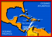 |
Cartagena, located in Colombia, at the north of South America, by the Caribbean Sea.
Cartagena de Indias enjoys a strategic location ideal for touristic, industrial and commercial developement.
View map |
|
|


